Freitag, 14. August 2020

Windhoek - VicFalls - PART 3 / English

Marabou Stork gliding above the Etosha Pan

Windhoek – Victoria Falls and back
PART 3 – Etosha National Park

Now we have two full days left within the Etosha National Park. Yesterday we explored the area west of the Etosha Pan, but only as far as our time budget allowed. Because after all, we still have a lot to do on our way from Okaukuejo towards Fort namutoni. Back, passing Okaukuejo and then another seventy kilometers eastwards to the Halai camp.
Etosha viewpoint - on a peninsula
 
As long as it's somehow possible, I always take enough time also for the eastern part of the national park, because that way we can also explore the area east of the Etosha- and around the Fischer pan from Fort Namutoni.

As already described in PART 2 of our tour, we entered the national park through the Andersson Gate, paid our permits and confirmed the accommodations, which of course we had already booked in advance.

Okaukuejo, Halali and also Fort Namu-toni were built by the then administra-tion of the German Protectorate of South West Africa as military and police posts, but all three of them served only secondaryly for military purposes. The main task was to contain the foot and mouth disease. So-called helio-graph stations, which were built on high observation towers in Okaukuejo and Namutoni and on a granite hill near Halali Camp, served as a means of communica-tion. The sunlight was focused through a lens, with which one could then send optical Morse signals.

Also right next to the Halali camp there is another, smaller granite hill, from which you can watch an artificial water hole day and night.

<< Etosha viewpoint - on a peninsula.

 
The Etosha Salt Pan was originally a huge lake of around 4,760 square kilometers that slowly dried up. Even today, the pan can fill up completely with water in a heavy rainy season, which happens very rarely and also causes only shallow water depths. The name Etosha means "Great White Space" in Ojiwambo, which indicates that this lake had already dried up since the immigration of the Bantu peoples. 
 
The pan is located at around one thousand meters above sea level and is part of the Kalahari Depression, which extends over large parts of Botswana and the east and north of Namibia. Together with the Cuvelai catch-ment area and Lake Opono, this forms a special wetland area in accordance with the “Ramsar Convention”.

Steenbokkie and Giraffe


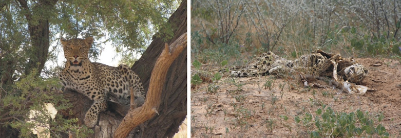
...so that's life - even the leopard "gets caught" ...at some point...
 
The first Europeans to come to the area in 1851 were the Swedish explorer John Charles Andersson and the English scientist Francis Galton who published their travelogues and made these salt pans famous in Europe that way.
A little later, in the 1860s, groups of “Dorsland Trekkers” (thirstland trekkers) coming from the Transvaal passed accross and alongside the salt pans on their way towards Angola. In 1876 the American traveling salesman Gerald McKiernan traveled through the Namib and reached the Etosha Pan, where he discovered fresh water springs around Okaukuejo.

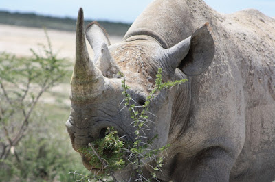
Black Rhino in the Andoni Plains
<<< Black Rhino in the Andoni Plains

As a browser, the Black Rhinoceros feed mainly on leaves, small branches, twigs and bark. In contrary to the White Rhinoceros, it only feeds on grass in exceptional cases. In the Etosha National Park, the various acacia species are the main source of nutrition.

The black rhinoceros prefers to stay well covered in the dense bush and lives mainly crepuscular and nocturnal.

White Rhinos are only found locally in Etosha National Park, because only during the rainy season, larger areas of grassland can be found.

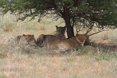
the Lion girls at the Aroel waterhole
The lion population is currently estimated at around 400 to 450 animals, which are distributed over the entire area of the national park.
 
Lions can also be found during the day, but hunt mostly at night, where they can take of their greatest advantage, the excellent eyesight in the dark.

Also and again today, it was worth it that we drove a lap around the fishing pan in the later afternoon ... - see here:

<<< the Lion girls at the Aroel waterhole

Tomorrow morning we will ride one more lap towards the Klein-Namutoni waterhole and around the famous Dik-Dik Drive.
After that we will continue via Tsumeb and Grootfontein towards Rundu ... - on the Okavango. The opposite bank already belongs to Angola.

Fort Namutoni: The view from the observation tower in the evening and a view of the fort in the early morning
Fort Namutoni: The view from the observation tower in the evening and a view of the fort in the early morning.


In this blog, we not only describe the tour itself and what we experienced. We also want to report on aspects of nature conservation, the history of the creation of the national parks and current events in connection with it. The present geology of the respective landscapes and their geological history also play an important role.
Klar – wir können in diesem Rahmen nicht alles ausführlich behandeln.

Sure - we cannot deal detailed with everything in this context. Therefore my request: Write in the comment column, your personal questions, which topics you are particularly interested in and what we should write more about.

We have also dedicated two pages to these topics on our website - namely:
- nature conservation and hunting .... >>>

- .... as well as nature conservation and tourism ... >>>


Current travel offers - for self-drivers as well as guided tours
- can be found on our website: www.paarl-safari.de
- or you send us an e-mail to: info@paarl-safari.de


Keine Kommentare:

Kommentar veröffentlichen