Dienstag, 14. Juli 2020

Windhoek - VicFalls - TEIL 3 / deutsch

Marabu-Storch über der Etosha-Pfanne
Windhoek – Victoria Falls und zurück
TEIL 3 – im Etosha Nationalpark

Wir haben jetzt noch zwei volle Tage innerhalb des Etosha Nationalparks zur Verfügung. Schon gestern haben wir die Gegend westlich der Etosha-Pfanne erkundet, aber eben nur soweit es unser Zeit-Budget zulässt. Wir haben schließlich danach noch einiges vor uns. Zurück, an Okaukuejo vorbei und dann nochmals gute siebzig Kilometer in östlicher Richtung bis zum Halai-Camp.
Etosha-Aussichtpunkt - auf einer Halbinsel
Wenn das irgendwie möglich ist, dann nehme ich mir im östlichen Teil des Nationalparks immer soviel Zeit, dass wir von Fort Namutoni aus auch die Gegend östlich der Etosha-Pfanne und um die Fischer-Pfanne herum erkunden können.

Wie schon in TEIL 2 unserer Tour beschrieben, sind wir durch das Andersson-Tor in den Nationalpark gekommen, haben unsere Permits bezahlt und die Unterkünfte bestätigt, die wir natürlich schon im Voraus gebucht hatten.

Okaukuejo, Halali und auch Fort Namutoni, wurden von der deutschen Schutzgebietsverwaltung als Militär- und Polizeiposten errichtet, dienten aber nur sekundär, militärischen Zwecken. Hauptaufgabe war die Eindämmung der Maul- und Klauenseuche. Als Kommunikationsmittel dienten sogenannte Heliogtaphen-Stationen, die in Okaukuejo und Namutoni auf hohen Aussichtstümen errichtet wurden und nahe dem Halali Camp, auf einem Granit-Hügel. Das Sonnenlicht wurde durch eine Linse gebündelt, womit man dann optische Morse-Signale senden konnte.

Direkt neben dem Halali-Camp liegt noch ein weiterer, kleinerer Granithügel, von dem aus man ein künstliches Wasserloch Tag und Nacht beobachten kann.

<<< Etosha-Aussichtpunkt - auf einer Halbinsel.

So ist das Leben - auch den Leoparden "erwischt es" ...irgendwann auch mal....

Die Etosha-Salzpfanne war ursprünglich ein riesiger See von etwa 4.760 Quatratkilometern, der langsam austrocknete. Auch heute noch kann sich die Pfanne in einer starken Regensaison komplett mit Wasser füllen, was sehr selten geschieht und auch nur noch geringe Wassertiefen verursacht. Der Name Etosha bedeutet auf Ojiwambo „Großer Weißer Platz“, was darauf hindeutet, dass dieser See schon seit der Zuwanderung von Bantu-Völkern ausgetrocknet war.

Die Pfanne liegt auf rund eintausend Höhenmetern und ist Teil der Kalahari-Senke, die sich über weite Teile Botswanas und den Osten- und Norden Namibias erstreckt. Zusammen mit dem Cuvelai-Wassereinzugssystem und dem Opono-See bildet diese ein besonderes Feuchtgebiet im Sinne der „Ramsar-Konvention“.

Steinböckchen und Giraffe


Als erste Europäer kamen im Jahr 1851 der schwedische Forschungsreisende John Charles Andersson und der englische Wissenschaftler Francis Galton in die Gegend und veröffentlichten Ihre Reiseberichte, die diese Salzpfannen in Europa bekannt machten.
Etwas später, in den 1860er Jahren zogen auch Gruppen von „Dorslandtrekkern“ (Durstland-Trecker) von Transvaal herkommend auf ihrem Weg in Richtung Angola durch- und entlang der Salzpfannen. 1876 reiste dann auch noch der amerikanische Handelsreisende Gerald McKiernan durch die Namib und erreichte die Etosha-Pfanne, wobei er in Okaukuejo Süßwasserquellen entdeckte.

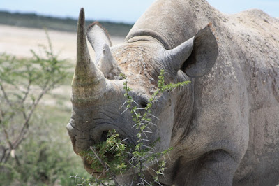
Spitzmaulnashorn in der Andoni-Ebene
<<< Spitzmaulnashorn in der Andoni-Ebene

Das Spitzmaulnashorn ernährt sich vorwiegend von Blättern, kleinen Ästen, Zweigen und Rinde. Im Gegensatz zum Breitmaulnashorn, frist es Gräser nur in Ausnahmefällen. Im Etosha Nationalpark sind die verschiedenen Akazienarten Haupt-Nahrungsgrundlage.

Das Spitzmaulnashorn bevorzugt gute Deckung im dichten Busch und lebt vor allem dämmerungs- und nachtaktiv.

Breitmaulnashörner kommen im Etosha Nationalpark nur Gebietsweise vor. Vor allem wohl deshalb, weil dort größere Grasflächen nur in der Regenzeit zu finden sind.
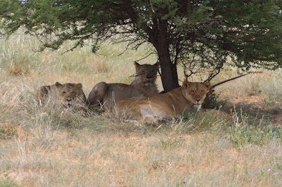
Löwen-Mädels am Aroel-Wasserloch
Die Löwenpopulation wird derzeit auf etwa 400 bis 450 Tiere geschätzt, die sich über die gesamte Fläche des Nationalparks verteilen.

Löwen sind zwar auch tagsüber anzutreffen, jagen aber überwiegend nachts. Wobei Sie ihren größten Vorteil ausnützen können, das hervorragende Sehvermögen bei Dunkelheit.

Auch heute hat es sich gelohnt, dass wir am späteren Nachmittag noch eine Runde um die Fischerpfanne herum gefahren sind... - siehe hier:

<<< Löwen-Mädels am Aroel-Wasserloch

Morgen früh werden wir noch eine Runde in Richtung des Klein-Namutoni Wasserlochs und den Dik-Dik Drive entlang fahren. Danach geht es dann über Tsumeb und Grootfontein weiter in Richtung Rundu... - am Okavango. Das gegenüberliegende Ufer gehört bereits zu Angola.

Fort Namutoni - abends der Blick vom Aussichtsturm und der Blick auf das Fort am frühen Morgen.

Wir beschreiben in diesem Blog nicht nur die Tour selbst und was wir dabei erlebt haben. Wir wollen damit auch über Naturschutzaspekte, die Entstehungsgeschichte der Nationalparks und über aktuelle Ereignisse im Zusammenhang damit berichten. Auch die Geologie der jeweiligen Landschaften und deren erdgeschichtliche Grundlagen spielen dabei eine wichtige Rolle.
Klar – wir können in diesem Rahmen nicht alles ausführlich behandeln. Deshalb meine Bitte: Schreibt in die Kommentar-Spalte, eure persönlichen Fragen, welche Themen euch besonders interessieren und worüber wir mehr schreiben sollten.

Diesen Themenkreisen haben wir auch zwei Blätter auf unserer Internet-Seite gewidmet – nämlich:
- Naturschutz und Jagd....>>>

- ....sowie Naturschutz und Tourismus...>>>


Aktuelle Tourangebote - für Selbstfahrer wie auch geführte Touren
- finden Sie auf unserer Internetseite: www.paarl-safari.de

- oder Sie senden uns eine E-Mail unter: info@paarl-safari.de

Sonntag, 5. Juli 2020

Windhoek - VicFalls - PART 2 / English

Windhoek – Victoria Falls and back
PART
2 – from Waterberg into the Etosha National Park

Farewell to Waterberg: Sunrise over the plateau - the memorial and a last dip in the pool.


Early in the morning - after breakfast - quickly into the pool and to the military cemetery, where the fallen of the Battle of Waterberg, in 1904, are commemorated - both German and Herero warriors. But after that we finally start - via Otjiwarongo - Outjo - Andersson Gate - into the Etosha National Park!

In transit through Otjiwarongo.
Otjiwarongo probably existed since long as a place for settlement place and it's name in Otjiherero language means "the beautiful place of the fat cattle".

Under German rule, the city was founded in 1892 and from 1900 onwards white settlers moved to places where before only a few Herero, Damara, Nama and Topnaar had previously lived.

In 1906 Julius Doll opened the first shop and connected Otjiwarongo to the Otavi Railway network. The old Henschel locomotive is still an industrial monument in front of the train station.

Otjiwarongo: The old Henschel steam engine of the Otavi railway.
The colloquial language is predominantly Afrikaans (around 90%) and German is also understood by around 35% of the residents. Languages within the ethnic group are of course also spoken, such as Khokhoewogab (a collective term for various dialects of Nama language family), Otjiherero and Oshivambo.

Also of interest in this context is the history of the Damara people, who are actually Bantus and most likely were part of the Herero peoples a long time ago. At some point they were captured by Namas and had to serve them as slaves over centuries. During this period, which only ended with the beginning of German colonial rule, the Damaras adopted the language and culture of the Namas and other Khoin peoples.

On the way between Otjiwarongo and Outjo – Heike and Anett.
Two other important institutions in Otjiwarongo and the surrounding area should also be mentioned: The crocodile farm, directly in the village and about 45 kilometers to the east, almost on the western steep slope of the Waterberg: The information, research and training centre of the international "Cheetah Conservation Fund".

This facility is part of a worldwide network of national parks, wildlife and nature reserves, zoological gardens, universities and various private institutions for the protection and conservation of the cheetah, the existence of which is threatened worldwide by various factors. On the one hand, there is the genetic bottleneck, which was created about thirty-five thousand years ago, when the entire genus, except for a few specimens of the subgenus "Acinonyx jubatus", died out. Since then the American and European cheetahs have disappeared and the cause of this mass extinction is still largely in the dark.
Since then, cheetahs have been found in the wild only in Africa and within a few isolated populations in Asia. Other problems are the loss of habitat and the associated fragmentation of natural occurrence. Inbreeding naturally has a further effect on the “genetic bottleneck” mentioned above.

That's why this worldwide network is so important for the maintenance and - as far as possible - even the improvement of the genetic reservoir. Unfortunately, today, we on our way havened had time for neither one. Not for the "Otjiwarongo Crocodile Farm" nor the "Cheetah Conservation Centre". We want to continue towards Etosha.

Our route from the Waterberg plateau to the Etosha National Park.


We did not make any detours today because we could not book for the first night in Okaukuejo (pronounced "okokuju") and therefore had to drive annother seventy kilometers to Halali.
In Outjo we stock up on "Braaivleis" - that means the meat for barbecue, and the drinks for tonight. Finally we reached  Andersson Gate, the southern access to the Etosha National Park.

Andersson Gate“ – the entrance into the Etosha National Park.
Here we fill in the forms for the national park permit, get it stamped and submit the reservations for our accommodation. We will have three overnight stays inside the park - twice in Halali and once in the old German Fort Namutoni. I could easily and comfortably spend three weeks in Etosha National Park without getting bored.

But still: We really have a lot to experience and even more routes ahead of us on this tour, so we must limit ourselves to these three overnight stays.

At the turn of the 19th to the 20th century, the game stocks in the north of the then "German Southwest Africa Protectorate" were so decimated by excessive hunting that there were already bottlenecks in the
Zebras at the Okaukuejo waterhole
meat supply of the local population.

This affected particularly Damaras and Ovambos, who depended much more on hunting than the settlers. Probably also because their meat growth in cattle farming was far below that of the commercial - mostly white - farmers. An additional factor was that their livestock, suffered greatly from the widespread foot-and-mouth disease.

In March 1907, Governor Friedrich von Lindequist put an area of almost one hundred thousand square kilometers as a nature and wildlife reserve under the protection of the government. The nature reserve was then more than four times as large as it is today.

Since around 1880 there had been no elephants in the area and the herds of antelopes, buffalos etc., which used to count ten thousand animals, had practically disappeared. The protective measures were successful and led to a gradual regeneration of the game populations. At the same time, however, the land requirements of the local population and the settlers grew.

In the course of the following years, the game reserve was reduced again in several stages and is now bigger than the size of Wales. However, since the turn of the last century, efforts have been made to connect the game reserves and biosphere reserves, as well as national parks, to form large protection zones across borders. The Etosha National Park is also the subject of such considerations.

....between Andersson gate and Okaukuejo....                               ....at the Okaukuejo waterhole....

At the Okaukuejo Camp we get the permits and pay the national park fees. At the NWR counter / Namibian Wildlife Resorts, we present our bookings for the next three nights. Of course, we paid for that well in advance.

"Cold drinks" and beer - a quick refreshment at the pool - a walk to the viewpoint at the Okaukuejo waterhole - a climbe-up to the lookout tower and then it goes on. We want to look east of the Etosha pans towards Okondeka and then past Okaukuejo towards Halali. We decide about the route we choose depending on what is to see there and what time it is - because: In any case, we have to be at the camp before dark and of course the reception should also be still open.

And really: there was so much to see that we already ran out of time on the first day in the national park ... - but see for yourself ... and that's just a very, very small section.

...Black Faced Impalas on a salt lick – in the middle of a „pad“....                                          ....refreshing on a waterhole...


.... kudu bull in the thick bush....                                     ...und springboks in the open area...

After a short rest at one of the viewpoints on the banks of the salt pan, we continue towards the Halali camp, where we will spend the night twice. We arrived just in time to collect our keys at the reception and to move into our chalets in daylight.

Later in the evening - when it was already dark we went to the Halali waterhole. A peculiarity, by the way. It is below a small hill from which you have a really good overview. However, you need good eyes and above all good hearing, because the surrounding bush is quite dense.

But you know anyway how it works like and what's to do... !!!

...our chalets in the Halali camp...                                                           ,,,and black rhinos at the Halali waterhole...


In this blog, we not only describe the tour itself and what we experienced. We also want to report on aspects of nature conservation, the history of the creation of the national parks and current events in connection with it. The present geology of the respective landscapes and their geological history also play an important role.
Klar – wir können in diesem Rahmen nicht alles ausführlich behandeln.

Sure - we cannot deal detailed with everything in this context. Therefore my request: Write in the comment column, your personal questions, which topics you are particularly interested in and what we should write more about.

We have also dedicated two pages to these topics on our website - namely:
- nature conservation and hunting .... >>>

- .... as well as nature conservation and tourism ... >>>


Current travel offers - for self-drivers as well as guided tours
- can be found on our website: www.paarl-safari.de
- or you send us an e-mail to: info@paarl-safari.de